Fire services across the country are battling bushfires burning in NSW, Victoria, South Australia and Tasmania. See below for a state-by-state breakdown of the latest warnings and updates.
Subscribe now for unlimited access.
$0/
(min cost $0)
or signup to continue reading
NSW
Where to find information
Current incidents in NSW according to the RFS - click each pin to view incident
#NSWRFS statewide update: 124 incidents 340 trucks 1126 Ffighters 63 Aircraft 53989.59 ha burnt. Stay safe #nswfires
— NSW RFS Media (@rfsmedia) January 8, 2013
THIS PAGE WILL NOT BE UPDATED UNTIL 6AM. FOR EMERGENCY INFORMATION VISIT THE NSW RFS WEBSITE OR CALL 1800 697 737.
1.00am update: Fire authorities are concerned about the impact of southerly winds on a major fire south of Nowra. The winds could push the flame north into the towns of Sussex Inlet and Wandandian, according to the South Coast Register. Evacuations are a possibility.
10.07pm update: A new emergency warning has been issued for a bushfire near Cooma.
The fire is burning in the Kybeyan Valley, west of Tuross River Road. The fire has reached properties in Hains Road and Warnocks Road.
People in the Kybeyan Valley area should seek shelter as the fire impacts. Police have been doorknocking homes in the area to advise them of the risk.
The fire is likely to move towards the Dangelong, Numeralla and Countegany areas following a southerly wind change expected after midnight. People in these areas should stay aware of the fire activity.
9.50pm update: As many as 20 properties could have been destroyed by a massive grassfire west of Ballarat today.
The Chepstowe-Pittong fire is active but contained, covering about 1100 hectares with a 17 kilometre perimeter. Some 250 firefighters are on site.
Authorities believe between six and 20 properties have been affected by the fire so far, the Ballarat Courier reports.
9.05pm update: From the Yass Tribune:
'Just got off the phone from Peter Dyce to get the situation from the horse's mouth, as it were.
The fire is heading towards BOOKHAM. He advises Bookham residents to put their fire plan into action. There will most likely be an automated warning going out now or very soon.
If you want to leave, now is the time to do it.
If you feel comfortable to stay, then be prepared to shelter in your home until the fire has passed. A taskforce from Goulburn was being dispatched as we spoke. Firies will create a ring around Bookham to protect properties.
Fire front is three kilometres long and travelling at about 15kph. It is estimated to reach Bookham in under two hours. Fire my also spread to BURRINJUCK.'
9pm update: One home has been lost, more than 1000 livestock killed and another 20 homes are under threat from a large fire at Jugiong, near Yass.
The grass fire is burning near rural properties between the townships of Jugiong and Bookham.
The fire is currently impacting on Burrinjuck Road and the fire activity has closed the road. People in the area are advised to shelter in place as the fire impacts. People in the Burrinjuck Dam area are also advised to shelter in place, it is too late to leave this area.
The fire has moved through the Childowla Road area, but residents are advised to keep up to date with the changing fire conditions.
Earlier this afternoon an Emergency Alert telephone warning was sent to residents on Childowla and Talmo Road advising them to leave the area immediately and go north to Harden.
It has been confirmed that one home was lost on Bogalara Road.
People in the Bald Hill are are advised that the fire threat has now eased, however they should remain aware of the changing fire situation.
8.40pm update: A southerly change will reach the Dean's Gap fireground by midnight, causing the fire to head in a northerly direction and impact on Sussex Inlet Road within the following few hours.
Rural Fire Service and Fire Rescue New South Wales firefighters are strategically deployed along the Sussex Inlet Road protecting properties.
The southerly change will bring cooler conditions however, the threat to property will remain.
8pm update: A southerly wind change has reached the Dean's Gap fireground, turning the fire north and dropping temperatures. It is now burning parallel to the Princes Highway. An emergency warning remains in place.
7.30pm update: The Dean's Gap fire, in the Shoalhaven, is now expected to jump the Princes Highway before 8pm, putting it less than 1.5 kilometres from the town of Wandandian.
People who have not already left the area and who rely on the Princes Highway to leave are advised that the Princes Highway is closed in both directions at Wandandian, between Wandean Road and Bendalong Road. It is too late for people to leave the area.
These people should prepare their homes and themselves for possible fire impact.
6pm update: A fire east of Bungendore, near Queanbeyan, has closed the Kings Highway between Braidwood and Bungendore. People on the northern side of the fire are advised they can still leave the area by travelling north up the Braidwood to Goulburn Road towards Tarago.
The fire has spotted over near Mulloon Road and properties may come under threat in this area.
Firefighters are working to protect properties. They are experiencing difficult conditions, with winds gusting at more than 100 kilometres an hour.
5.30pm update: The Sydney Morning Herald has posted raw vision of fires in the Shoalhaven area.
5.20pm update: RFS Incident Controller Ian Stewart has told media that the Dean's Gap fire is too intense for direct firefighting at the moment. He has advised residents of Wandandian and Sussex Inlet to stay where they are, as it is too late to leave the area.
Listen to Mr Stewart's comments on the Dean's Gap fire
4.50pm update: Nowra resident Jai Woolveridge speaks to digital journalist Bevan Shields about the mood in the town as the Dean's Gap fire gains momentum.
4.45pm update: An emergency warning is in place for a fire burning near Bungendore, north-east of Queanbeyan.
The fire is burning in the area of the Kings Highway near Timber Hills Road.
The fire may impact on properties later today.
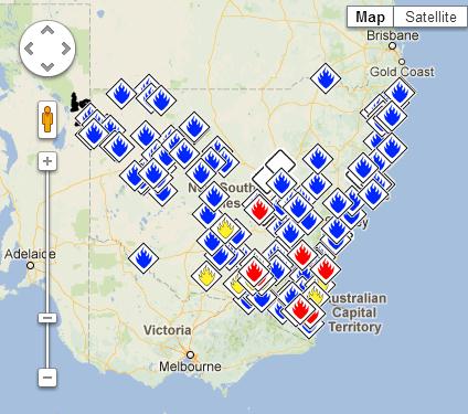
4.20pm update: To give an idea of the scale of the task facing NSW firefighters, here's what the RFS incident map looks like at the moment:
Meantime, the Munyabla (Lockhart) fire has been contained, and its warning downgraded to Watch and Act.
4.15pm update: Emergency warning for Grabben Gullen, north-west of Goulburn and south of Crookwell.
A grass fire is burning out of control near Range Road and Leary Lane. It could impact properties anytime in the next two hours.
4pm update: Fires with emergency warnings in NSW:
*Brogo (Bega Valley)
*Bogan Gate (west of Parkes)
*Tarcutta (near Wagga Wagga)
*Yarrabin (near Cooma)
*Dean's Gap (Shoalhaven, near Nowra)
*Munyabla (Lockhart) (near Wagga Wagga)
3.50pm update: The Dean's Gap fire has closed the Princes Highway at Wandean Road in Wandandian.

3.45pm update: Fire is threatening the town of Bogan Gate, west of Parkes. Residents should shelter where they are until the fire front passes.
3.30pm update: An emergency warning has been issued for the Dean's Gap fire, south of Nowra, which broke containment lines earlier today. The fire is between two and six hours from properties in:
Bendalong Road, Bendalong, North Bendalong, Cunjurong Point, Janung Lane, Jerrawangala, Sussex Inlet Road, Sussex Inlet, Cudmirrah, Swanhaven, Medlyn Ave, Berrara.
Residents of these areas should leave now if it is safe to do so.
Earlier today, three families were evacuated from a Scotts College camp in the area while Bream Beach and Wrights Beach camping areas at Erowal Bay have also been emptied of visitors.
The gates to the Beecroft headland near Currarong have been closed and all campgrounds evacuated.
Boats in that area were moved to Callala Bay.
Naval personnel from HMAS Albatross west of Nowra have put fire patrols on standby in the area, and two navy Sea Hawk helicopters are on standby at the base to assist with water bombing if necessary.
3.20pm update: Firefighters are making progress in controlling the Munyabla (Lockhart) fire, although it is still moving east towards the town of Henty.
Elsewhere, the "Valema" fire at Oura, near Wagga, remains out of control and could impact properties in six hours.
3pm update: The Bureau of Meteorology has issued a warning that winds of up to 100km/h could hit the South West Slopes, Snowy Mountains, Southern Tablelands, Illawarra and ACT this afternoon.
2.37pm update: The Deans Gap fire has now closed Main Road 92 between Braidwood and Nowra.
2.30pm update: A fire near Nowra, on the South Coast, has broken containment lines. The Deans Gap fire had been controlled overnight, but is now burning uncontrolled 12km west of Wandandian.
View Yarrabin fire in a larger map
2.15pm update: An emergency warning has been issued for residents of Narrandera, south-east of Griffith. The fast moving grass fire is heading in a south easterly direction towards Lake Coolah.
1.30pm update: Emergency warnings have been issued for two fires near Wagga. An out of control fire is expected to impact properties at Munyabla (Lockhart), east of Wagga. It is too late to leave - residents should shelter where they are.
The second fire, three kilometres north-west of Tarcutta, is between two and six hours from properties in the Tarcutta area. It is now too late to leave the area, and residents should prepare for the arrival of the fire front and shelter where they are. The Hume Highway will be closed in the area.
1.20pm: A bushfire burning at Tarcutta, east of Wagga, could impact on the Hume Hwy. The five hectare fire is burning near Mates Gully Road and Blythes Road.
1.10pm update: The Fire Danger Rating in the Riverina region has been upgraded to Catastrophic, with the Lower Central West Plains expected to reach the same rating this afternoon.
View Brogo fire in a larger map
1pm update: The Yarrabin fire is ''spreading by the minute'', one volunteer has told The Canberra Times.
'The volunteers on the ground can no longer keep track of how large the fire is, one saying that it was "spreading by square metres by the minute".
Local residents say the fire has been burning since Sunday, and the paddocks surrounding the battered woolshed where crews have gathered are little but blackened earth and bare trees.
Winds remain one of the biggest issues for crews, with gusts reaching 50km/h. One volunteer described driving into the fire ground as like being met with "a wall of smoke".'
12.40pm: A Watch and Act warning has been issued for a fast moving grass fire at Conargo, north-west of Jerilderie in the NSW Riverina.
The fire, which has burnt through more than 2000 hectares of land, is travelling east, close to the Newell Highway. Motorists should avoid the area.

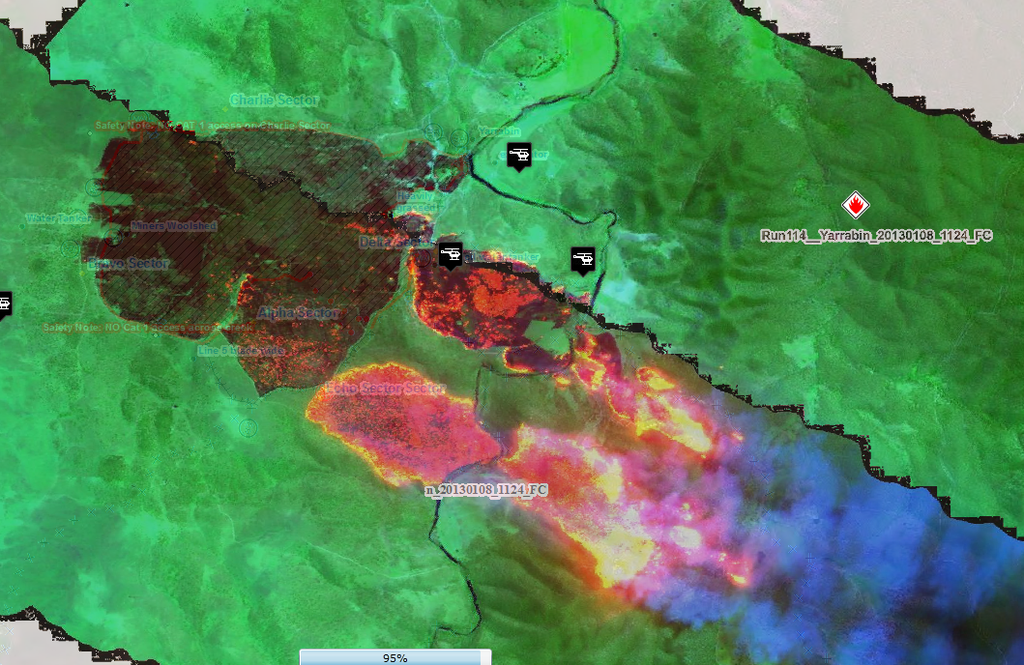
12pm update: The RFS has released a digital image showing the extent of the Yarrabin fire.
11.45am update: RFS Commissioner Shane Fitzsimmons has warned that up to 20 homes may be at risk from an out of control bushfire at Brogo, near Bega.
11.30am update: The Brogo fire will impact homes east of Warrigal Range Road or west of Eagles Nest Road by approximately 12.45pm, the RFS says. Residents should evacuate to Bega.
11.15am update: An emergency warning has been issued for Bega Valley residents in Warrigal Range Road Brogo, north of Bega. Residents should evacuate to Bega.
11am update: The RFS have repeated a warning for people to leave mowers in the garage today, after a fire near Bathurst was started by someone mowing their lawn.
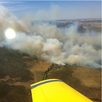
10.30am update: The Yarrabin fire, near Cooma, is now impacting on rural properties, with firefighters working to save homes.
A RFS aerial photo showing the Yarrabin fire
The fire is burning in a south easterly direction and has crossed over the Numeralla River in the direction of the Kybean Valley. It is expected to reach this area by around 2pm.
People in the Kybean Valley area are advised to leave now and go to Nimmitabel township immediately. Police are doorknocking homes in the area to advise them of the risk.
10.25am update: A fire at Oura, near Wagga Wagga, has been upgraded from advice to Watch and Act as winds in the area pick up. The fire threatened the village of Oura yesterday before it was brought under control.
10.15am update: Shoalhaven City Council Mayor Joanna Gash is urging those living or holidaying in the fire prone region to move into urban centers for the day.
“If you are worried at all, you need to leave and go into town," she said.
"Even if it turns out that we are crying wolf, it is better off to be prepared and have everyone safe.”
Mrs Gash, who is also the Federal MP for the area, said the majority of visitors had left the region's national parks but some remained.
The region has been given a rare ‘Catastrophic’ Fire Danger Rating, meaning there is a serious risk hundreds of homes and lives could be lost. It is the highest possible risk rating.
Some elderly residents had been contacting her office and the council after receiving text messages last night advising them to leave bushfire prone areas, she said.
9.50am update: Temperatures are edging close to 40 degrees at Bega, in southern NSW, while Albion Park, in the Illawarra, is already at 33.9 degrees. It is 30.4 degrees in Gosford, 30 in Goulburn and 30 in Cooma.
9.40am update: It is now too late to leave for residents in the path of the Yarrabin fire, near Cooma, the RFS says. Those still in the area should seek shelter immediately and remain there until the fire front passes.
9.25am update: The RFS now says the Deans Gap fire, in the Shoalhaven, is under control.
More than 25 fire crews worked through the night to control the fire, which is burning 12km to the west of Wandandian.
9am update: An emergency warning has been issued for residents in Carlaminda, near Cooma, after a fire broke containment lines this morning.
The Yarrabin fire, which is more than 500 hectares in size, will impact properties within 20 minutes.
7.10am update: In an extraordinary move, the NSW RFS has urged people living or holidaying in Wandandian, Sussex Inlet, Swanhaven, Cudmirrah and Berrara to move to the centre of Nowra or Ulladulla by 8.00am due to the deadly bushfire threat facing the NSW south coast.
A small bushfire was last night burning about 12 kilometres west of Wandandian and there are concerns the fire may flare later today.
"Should the fire escape containment lines, a rapid spread towards the east would occur," the NSW RFS warned. "Based on a model prediction, the rate of spread may be upwards of three kilometres per hour."
7.00am update: The NSW RFS estimates about one million emergency text messages were last night sent to residents in the Illawarra, Shoalhaven and Southern Ranges areas. The messages warned of the Catastrophic Fire Danger Rating in those areas today.
Monday:
7.15pm update: The NSW RFS is sending emergency alert SMS messages to all residents in areas declared 'catastrophic' fire danger areas tomorrow, urging them to avoid bushfire-prone areas.
4.30pm update: The "Valema" Oura fire, burning north of Wagga Wagga, has been downgraded from an emergency warning to a Watch and Act warning. While the RFS has advised the fire is not contained, it is no longer directly threatening properties.
4.15pm update:
The fire broke out this afternoon between Gunning and the Belmont Forest and has raced through more than 25 hectares.
Crews are concentrated around the Laidvale Rd and Gundaroo Rd areas.
The outbreak overtook a RFS truck just after 3pm.
The Snowy Hydro Southcare helicopter has been deployed to transport the man to Canberra Hospital.
VICTORIA
Where to find information
9.05pm update: All bushfires in Victoria are now at Watch and Act level or lower.
7.20pm update: Residents of Carngham have been evacuated as the Chepstowe fire bears down on the town. Properties are expected to be impacted between 7.15pm and 8.15pm.
6pm update: Andrew Eales, Editor of Ballarat's Courier newspaper, reports that 100 people have been evacuated from Lake Burrumbeet, west of Ballarat. The area is under threat from the Chepstowe fire.
View Drik Drik fire in a larger map
4.50pm update: Nowra resident Jai Woolveridge speaks to digital journalist Bevan Shields about the scene in the town as the Dean's Gap fire gains size and momentum.
4.45pm update: There is a medium, fast moving grassfire in the Chepstowe area.
It is travelling in a north-easterly direction.
View Tasmania fires - January 7 in a larger map
This fire is expected to impact the Beaufort-Carnghan and Station Lane intersection immediately.
This grassfire is approximately 50 hectares in size and is out of control.
2.50pm update: The Sunbury fire has now been downgraded to advice, with no properties currently at risk.
2.10pm update: An emergency warning has been issued for a fast moving grass fire at Sunbury, north-west of Melbourne. The fire could hit the rear of properties at Baggy Green Street and Vineyard Road in Sunbury.
9.50am update: A Watch and Act warning remains in place for the Drik Drik fire, near Portland in the south-west. The fire has reached 7050 hectares and is still out of control.
Temperatures across the state are forecast to reach the mid to high 30s, with showers and storms also expected.
Monday
3pm update: An emergency warning has been issued for a large bushfire at Drik Drik, in the state's south-west. The large, slow moving fire is expected to impact the town of Drik Drik between 4.30 and 7pm today. Residents should decide now whether they will leave or stay and defend their property.
TASMANIA
Where to find information
3.45pm update: The Mathinna fire has been downgraded, with all Tasmanian bushfires now at Watch and Act level or lower.
3pm update: An emergency warning has been issued for Mathinna, in the state's north-east. A fire front is expected to hit the area in the next hour. Residents are advised to leave, only if it is safe to do so.
2.40pm update: The Holwell fire has been downgraded to Watch and Act, but a new emergency warning has been issued for the Forcett fire. The TFS advises:
"Residents of Kellevie and Bream Creek areas, and all surrounding areas east of Bream Creek, are asked to relocate to a Nearby Safer Place NOW.
Kellevie residents and surrounds are asked to head north to Orford via Wielangta Road.
Residents of the Bream Creek area are to relocate to Marion Beach via Marion Bay Road NOW."
2pm update: The TFS has issued an emergency warning for a second fire near Flowery Gully. The Holwell fire will impact Stewarts Road, Holwell Road, Nettlefolds Road and Flowery Gully Road within half an hour.
1.20pm update: An emergency warning has been issued for Flowery Gully, north of Launceston. Stewarts Hill, Holwell Road, Nettlefolds Road, and Flowery Gully Road will all be at direct risk from fire within half an hour.
11.55am update: An emergency warning has been issued for the massive Forcett fire, as strong winds cause flare-ups.
Fire is impacting on Eaglehawk Neck, Pirates Bay, Doo Town, Old Jetty Road and Blowhole Road People in this area need to evacuate now to their Nearby Safer Place either Pirates Bay boat ramp or Eaglehawk Neck Beach.
Monday
7.10pm update: The Tasmania Fire Service has downgraded the Montumana fire to a 'Watch and Act' incident.
However, the fire is still affecting the Mawbanna community and may affect residents in the Yanns Road and Loosemores Road areas as well as Mawbanna, Montumana, Sisters Beach, Rocky Cape, Hellyer Beach, Detention River and Crayfish Beach within the next 12 hours .
Mawbanna Road has reopened and community members are able to return to their residence but should remain vigilant and have their bushfire plan activated.
3.15pm update: An emergency warning has been issued for a large bushfire at Montumana, with the fire directly impacting on Mawbanna now.
The TFS has warned of spot fires up to one kilometre from the fire front.
SOUTH AUSTRALIA
Where to find information
No major warnings as of 7.00am Tuesday.
QUEENSLAND AND NORTHERN TERRITORY
Where to find information
No major warnings as of 7.00am Tuesday.
AUSTRALIAN CAPITAL TERRITORY
Where to find information
No major warnings as of 11am Tuesday.